
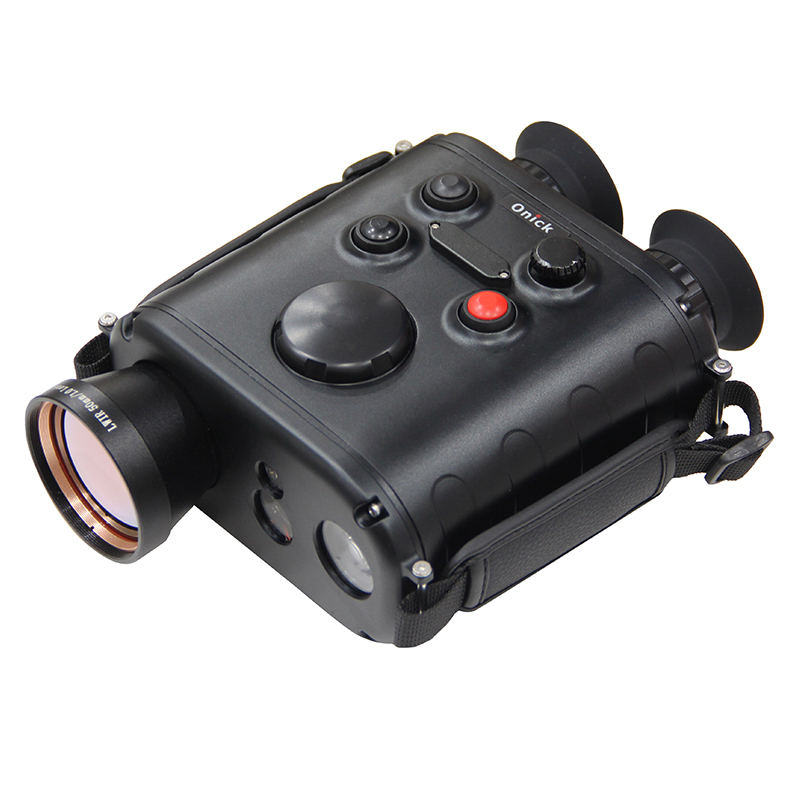
Products Description
The Onick RE650 is a handheld tri-light thermal imaging reconnaissance device equipped with a television camera, uncooled infrared thermal imager, laser rangefinder, GPS, and electronic compass. It can perform all-weather, day and night reconnaissance and target location. This product boasts excellent infrared imaging performance, is compact and lightweight, consumes little power, is easy to operate, and has a comfortable grip. It utilizes a high-resolution infrared sensor, providing excellent infrared imaging, ultra-low power consumption, fast start-up, simple operation, and a compact and stable structure.
Main Functions:
1. Infrared and white light imaging, binocular observation, image and video storage;
2. Electronic zoom: 1.0×~8.0× stepless zoom, 0.1× increments;
3. Laser ranging, BeiDou positioning, compass orientation, target positioning, and ballistic calculation functions;
4. Reserved expansion interface for connecting external humidity sensors, anemometers, etc.;
5. Features fog penetration, roll angle, pitch angle, altitude, barometric pressure sensor, and fault diagnosis functions;
6. AI target recognition for people and vehicles; lock-on recognition of drones;
Application Areas:
Suitable for low-altitude economic activities, emergency rescue, counter-terrorism, reconnaissance, border defense, drug enforcement night vision, border patrol, border checkpoint monitoring, maritime search and rescue, prison monitoring, night vision patrol, and epidemic prevention, etc.
Technical parameter
| Infrared Thermal Imager | |
| Detector | 640×512, 12µm vanadium oxide uncooled focal plane array; |
| Lens | 50mm, F1; |
| Field of View | 8.8°x7° |
| NETD | 50mk |
| White Light Camera | |
| Detector | 3840×2160, 1.5µm color CMOS; |
| Lens | 35mm, F1.8; |
| Fog Penetration Ratio | 1.5 |
| Field of View | 3.0°×2.2° |
| Fog Penetration | Yes |
| Laser Rangefinder | |
| Wavelength | 905nm; |
| Range | 10~6000m; |
| Range Accuracy | ±0.2m; |
| Range Mode | Supports single ranging and continuous ranging; |
| Accuracy | ≥95%; |
| Repetition Rate | ≥1Hz; |
| Number of Range Measurements | ≥20000; |
| Display | |
| Display | 0.39-inch OLED; |
| Resolution | 1024×768; |
| Optical Magnification | 15x; |
| Electronic Zoom | 1.0x~8.0x stepless zoom, 0.1x increments; |
| Eyepiece Power | -4D~4D; |
| DDE Digital Detail Enhancement | 0-255 adjustable; |
| Storage | Built-in 64GB; |
| Storage Capacity Display | Supported, displayed in the upper right corner of the screen; |
| Battery Power Display | Supported, displayed in the upper right corner of the screen, 3 bars for full display, red when battery is below 10%; |
| Time Display | Supported, format "Year-Month-Day-Hour-Minute-Second"; |
| Target Ranging | Supported, yellow indicates ranging is not enabled or invalid, white indicates normal ranging or valid ranging distance; |
| Infrared Brightness Adjustment | Supported; |
| Infrared Enhancement Adjustment | Supported, adjustable infrared enhancement level, 1, 2, 3. Level 4; |
| Infrared Image | Switchable between white-hot and black-hot modes |
| Positioning Module | |
| BeiDou Positioning | Supported. Device location is displayed sequentially as latitude, longitude, and altitude W: West longitude E: East longitude, N: North latitude, S: South latitude, H:Altitude |
| Compass Orientation | Available |
| Target Positioning | Supported. Target location is displayed sequentially as latitude, longitude, and altitude W: West longitude, E: East longitude, N: North latitude, S: South latitude, H: Altitude; |
| Positioning Mode | BeiDou or BeiDou + GPS, azimuth accuracy ≤ 0.5°; |
| Self-Positioning Accuracy | Horizontal positioning (CEP) ≤ 10M, Elevation positioning accuracy (PE) ≤ 10 meters; |
| Target Positioning Accuracy | Observation Positioning accuracy ≤20M (CEP) at a distance of 2KM; |
| Ballistic calculation | Supported |
| AI recognition | AI recognition of people and vehicles |
| Drone lock-on | Supported, can automatically lock onto and recognize drones; |
| Fog penetration | Supported |
| Barometric pressure sensor | Supported; |
| Horizontal angle, roll angle, pitch angle | Yes, horizontal angle:range 0-360°; pitch angle: ±180°; roll angle: ±180°; |
| Current ambient temperature display | Supported |
| Fault diagnosis | Supported |
| Recognition distance | Infrared recognition : People (1.7x0.5m) 2000m, Vehicles (4.6x2.3m) 4800m |
| Visible light recognition | Human (1.7x0.5m) 4800m, Vehicle (4.6x2.3m) 6000m |
| External Interfaces | |
| Video Output | HDMI; |
| Image and Video Export | USB, supports external power supply |
| Ethernet Port | Yes |
| Features display, video storage, playback, and deletion control functions | |
| MTBF (Mean Time Between Failures) | ≥1500 hours |
| Operating Time | Not less than 5 hours (at room temperature 25°C) |
| Operating Temperature | -40°C to +50°C |
| Protection Rating | IP67 |
| Dimensions | 210*135*78.9mm |
| Weight | 1.45kg; |
| Includes | Main unit (including battery and wrist strap), charger (including power adapter), spare battery, storage case and stand, instruction manual, lens cloth, certificate of conformity, etc. |
| Tripod | Supported (aluminum alloy tripod + gimbal kit) |
")
")
")
")
")
Tags: